 In
june 1980, the second of three voyages to Scotland leads me to
Edinburgh,
Crianlarich, the wild west of the Crampian Mountains and the lovely
valley
of Glen Affric. I make all the way by hitchhiking, a fact that brings
me
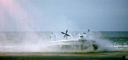
right onto the hovercraft. Usually I take the ferry boat,
preferably the fast boats of Townsend Thorensen, i.e. the Herold of
Free
Enterprise and related names. Since I came to know that they were so
fast
because they shut the doors off shore I can't recommend them any more.
Anyhow, this time I take a kind of aircraft, pretty speedy and not too expensive, the fastest way to get across.
 Until end of September 2000 the last two hovercrafts, named «Princess Margret» and «Princess Anne», will make their way back and forth the Channel, at a maximum speed of 100 km/h. I do not like that way of crossing because I feel like being trapped in a big tin can. As the windows are always blind of sand or foam you miss the scenery. Hovercrafts are like Porsche cars: Best seen from the outside, too loud inside...
 *
*
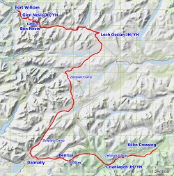
(The following maps were made from OSM Data using
GNavigia.)
This journey is my fastest. Thanks to the speed boat, good connections in London and pretty
good lifts all over the country I don't need much more than 24 hours to get to Scotland. I
decide to do a bit of walking in the most lovely area around Clencoe. Though having a wonderful
time I have to disclaim:«What you are reading about is not apt to be done again. Being on your own in the vastness of the scottisch mountains is really dangerous. If you break your leg you run the risk of being lost 'til a shepherd will find you the next season.» May be that the invention of mobile telefons will do the trick today, may be that the place I talk about is too far off all telefon nets. All I can do in 1980 is carrying good maps. As a land surveyor, I get along with that quite well. I like the «one inch series» of ordnance survey maps. Since 2012, grace to new Internet features, the OpenStreetMap community and a program I wrote to explore GPS data, I am able to tell the track's length of the hike: about 90 miles. There is a KMZ-File as well.